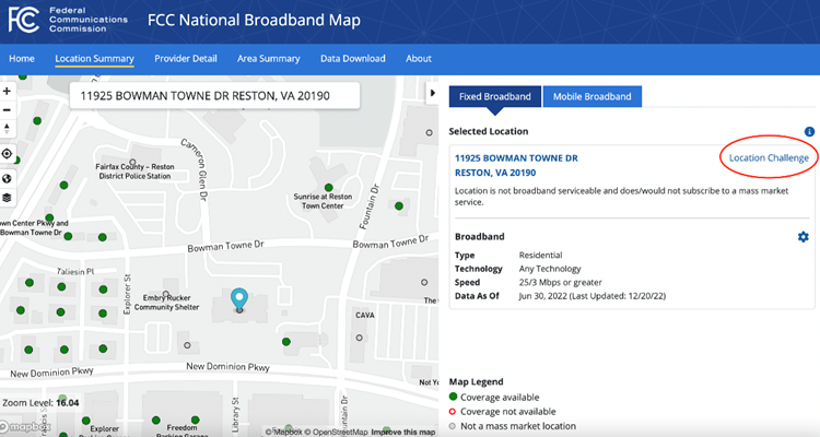
The FCC’s National Broadband Map shows Broadband Serviceable Locations (BSLs), or locations (or buildings) in the United States and its territories where mass-market fixed broadband internet access service is or could be installed. Location points where such service is available are green and points where service is unavailable are red (unserved) location points. The map also shows locations that are not BSLs in grey.
Because the FCC has determined that most community anchor institutions (CAIs), such as schools, libraries, and medical care facilities, are more likely to subscribe to customized, enterprise-grade internet service (as opposed to mass-market internet service), CAIs are generally represented by grey dots on the map. If a CAI actually does subscribe to mass-market internet service, or would subscribe to mass-market internet if it were available at the location, the location should be identified as a BSL (red or green point). Changing the status of the CAI to a BSL is easy to do using the Location Challenge function on the map interface. The steps to do so are below.
- If a CAI on the map is represented by a grey point but you believe it should be a BSL, click on the point, and then click on “Location Challenge” on the right side of the page.

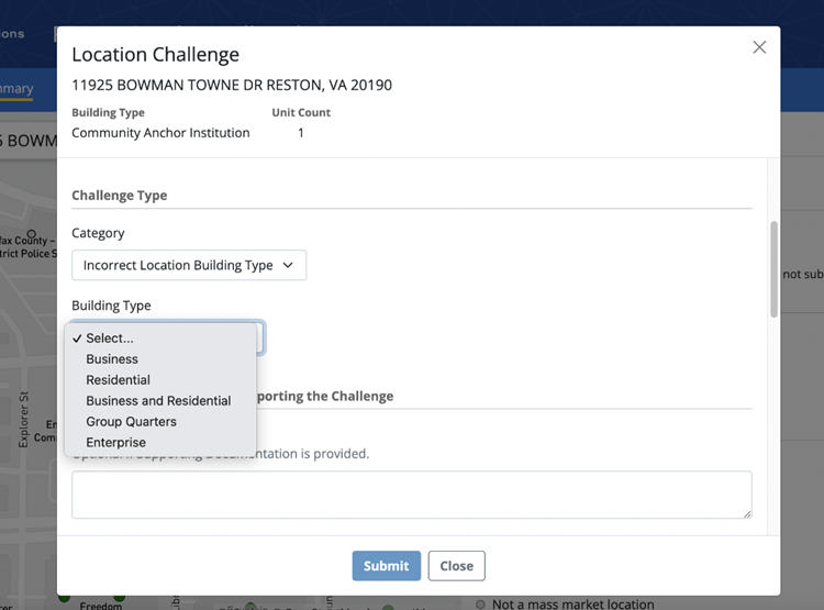
- In the window that appears (see screenshot below), fill in the required information. Under “Category” select “Incorrect Location Building Type,” then, under “Building Type,” select a new building type for the location. Selecting either “business,” “residential,” or “business and residential” will indicate that you want to change the location point to a BSL, or a mass-market broadband location, on the map. Select the option that aligns with the type of mass-market service the location currently subscribes to, or would subscribe to if service were available, i.e. a residential broadband service plan or a mass-market business broadband service plan.

- Insert a description for why you are submitting the challenge. You have the option to attach any supporting documentation. Check the certification and click “submit.”
The National Broadband Map is designed to collect and display data about locations where mass market fixed broadband internet access service is or could be installed. Once the building type is changed from CAI to “business,” “residential,” or “business and residential” in the next version of the Fabric, this will allow internet service providers to report in the FCC’s Broadband Data Collection the mass market services they make available to the location.
Learn more about what happens when you submit location challenges.